| |
Introduction |
| |
|
| |
The
continental shelf of Vietnam comprises several major Tertiary
basins, of which the petroleum potential has been confirmed
including Song Hong Basin, Phu Khanh Basin, Cuu Long
Basin, Nam Con Son Basin and Malay-Tho Chu Basin. |
| |
|
| |
Recent
studies indicated the estimated reserves and resources,
both onshore and offshore Vietnam to be 3-4 billion cubic
metres (BCM) of oil and gas, comprising 0.9-1.2 BCM of
oil and 2.1-2.8 BCM of natural gas. About 50 oil and gas
prospects have been found with reserves of approximately
3 billions barrels of oil and 23 TCF of natural gas. Commercial
oil has been discovered and produced in Cuu Long, Nam
Con Son and Malay-Tho Chu Basins, while commercial gas
is being produced in Song Hong and developed in Nam Con
Son and Malay-Tho Chu Basins. |
| |
|
| |
Cuu
Long Basin is now considered to be mature, with greater
than 50% probability that more than 50% of the total petroleum
in the region has been discovered, generally covered by
extensive seismic grid and high drilling density. Submature
regions such as Song Hong, Nam Con Son and Malay-Tho Chu
Basins have a greater than 50% probability that less than
50% of the region's total petroleum resources has been
discovered with medium seismic and drilling density. Phu
Khanh Basin and frontier areas are those without petroleum
discoveries, where seismic coverage is sparse and with
few
wells drilled. |
| |
|
| |
|
| |
|
| |
Regional
Geological Setting |
| |
|
| |
Tectonic
Evolution |
| |
The
Vietnam continental shelf area constitutes a part of a
system of Cenozoic sedimentary basins that lies within
a transition zone from the continental crust of the Indochina
Craton to the sub oceanic crust of the eastern deep water
basins. The basins developed here are rift basins with
multiphase history. Tectonic evolution of the East Vietnam
Sea Cenozoic Basins can be divided into the following
main stages: |
| |
|
| |
1.
Late Cretaceous-Eocene: pre rift uplift/initial rifting
phase. The major tectonic event is the collision of India
and Eurasia, resulted in the southeastward extrusion in
Indochina, represented by strike-slip movements. In Late
Eocene a change in the spreading direction in the SE Pacific
resulted in the development of a new NE-SW subduction
zone. |
| |
2.
Late Eocene-Oligocene: main rifting phase/initial ocean
floor spreading phase. This was the most powerful, resulted
in the development of most of the main structure elements
in the basins. The dominating style of the deformation
was extension and transtensional. |
| |
3.
Early-Middle Miocene: regional subsidence/renewed rifting.
In the majority of the basins, there happened a shift
from the rift to the thermally controlled high-rate subsidence.
Significant tectonic pulses occurred at the end of this
period marking a major inter basinal inversion event. |
| |
4.
Late Miocene: partial inversion/regional subsidence. During
this stage, the whole area became dominated by compression,
which, in combination with the dextral strike-slip fault
system east offshore Vietnam, might be the driving force
for the contemporary basin uplift and partial inversion
in most of the basins. |
| |
5.
Pliocene-Pleistocene: regional subsidence/renewed rifting.
The tectonic activity at that stage was diverse in different
basins, from low to moderate-amplitude differential uplift.
The high-rate fault bounded subsidence in the outer area
can be considered as the rifting activation phase associated
with the spreading of the deepwater basins. |
| |
|
| |
Depositional
Evolution |
| |
The
main regular sedimentation along Indochina margin were
defined by rate of subsidence and structure of the basement,
location of large river system of the South East Asia,
eustatic sea level changes and paleoclimate factor. The
basins are characterised by high sedimentation rates,
abrupt facies changes, abrupt thickening of sedimentary
sequences over short ranges, numerous unconformities and
scattered volcanic/extrusive activity. |
| |
|
| |
1.
Palaeocene-Eocene: sediments with great thickness were
deposited in the fluvial-lacustrine/coastal plain/deltaic
conditions |
| |
2.
Oligocene: time of maximum development of the non-marine
to transitive deltaic/coastal plain conditions, including
lacustrine and estuarine environments, which posses the
main source potential in the basins all over the Indochina
margin. |
| |
3.
Early-Middle Miocene: within the period, sedimentation
was simultaneous with a sea level eustatic rise. The rifting
caused a rapid increase in subsidence rate in all the
basins, resulted in the westward regression of the delta/coastal
plain systems. |
| |
4.
Late Miocene: the marine transgressive deposition continued,
but its rate was reduced. The shelf edge carbonate platforms
were deposited in most of southern basins. |
| |
5.
Pliocene-Pleistocene: sediment input increased, associated
with high-rate of subsidence in almost all the basins.
Rapid eastwards progradation of the shelf edge of the
basins were accompanied by deposition of submarine fan
slope systems. |
| |
|
| |
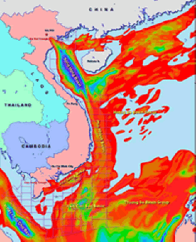
Location
of Tertiary Basins in Vietnam |
| |
|
| |
|
| |
|
| |
|
| |
|
| |
Song
Hong Basin |
| |
|
| |
Geological
Development |
| |
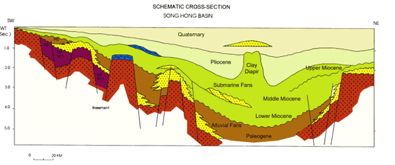
Song
Hong Basin, the largest Tertiary basin in the continental
shelf of Vietnam, is classified as a pull-apart system,
filled up with up to 15,000 m of Eocene to Recent sediment,
evolving in several phases throughout Oligocene to Pliocene
times. The onset of the basin's formation is related to
the collision of the Indian sub-continent with Asia during
the Late Eocene. |
| |
|
| |
Left
lateral strike-slip and pull apart along the Song Hong
Fault Zone in which two main fault systems formed the
eastern and western limits of its main depocentre controlled
the shape of the basin. The Eocene-Oligocene marked the
major rifting phase. Sedimentation was primarily in fluvio-lacustrine
environment, reflecting the restricted nature of the basin
coupled with rapid sediment filling.
|
|
|
| |
The
Early-Middle Miocene was a quiescent marine sedimentation
period. Carbonate development along shelf boundary prolonged
and backstepped in areas during the Middle Miocene sea
level transgression. Throughout the Late Miocene to Plio-Pleistocene,
abundant clastic sediment continued as a result of thermal
contraction and subsidence. |
| |
|
| |
|
| |
|
| |
Petroleum
System |
| |
Two
potential source rocks have been identified in the basin:
Oligocene lacustrine oil prone shales and Oligo-Miocene
deltaic/paralic gas-prone coals/coaly shales. Modeling
results indicate that most of the basin is mature for
gas (Kerogen type III/II). Paleogene sediments are mature
for oil only in the northwestern part and in some of the
half-graben area in the western margin of the basin.
|
|
|
| |
Reservoirs
in the basin comprised predominantly of Miocene/Oligocene
clastic sediments associated with rifting and subsequent
thermal contraction and sag. The carbonates including
carbonate build-ups and reefs can be found in the basin's
central parts or margins where uplift has occurred caused
by listric faulting. Fractured basement could also be
an exploration target.
|
|
|
| |
The
major trap types in Song Hong basin are rollover folds,
tilted fault blocks, basement high and carbonates buildups.
The dominant seal in the Song Hong Basin is the Tertiary
seal and although there is very little regionally correlatable
shale across the basin, local shales forming intraformational
seals are numerous and appear to be very competent. |
| |
|
| |
Prospectivity |
| |
Song
Hong Basin is assessed to contain 15% of the total hydrocarbon
resources of Vietnam. The major petroleum plays in the
Song Hong Basin include: |
| |
-
Pre-Tertiary fractured granite drape across basement
high blocks
- Oligocene/Miocene
sandstones structure associated with tilted fault
blocks, basement blocks or inversion
- Oligocene/Miocene
sandstones stratigraphic plays (especially turbidites)
- Middle
Miocene carbonates reef platforms
|
| |
There
are 4 petroleum contracts that remained in active
in the Song Hong Basin. There is one small producing field,
and another is being developed at the onshore northwestern
part of the basin. In the southern area, a number of significant
gas discoveries were made, but unfortunately contaminated
by high CO2 content.
|
|
|
| |
|
|
|
| |
Phu
Khanh Basin |
| |
|
| |
Geological
Development |
| |
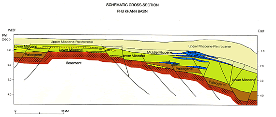
Phu
Khanh Basin is a present deepwater basin. It shows characteristic
rift structures, which belong to the transtensional system
developed along the mega shear zone at the boundary between
the relatively rigid continental block and the more mobile
spreading zone of the East Sea. |
| |
|
| |
The
Basin was formed during the Oligocene to Early Miocene
main rifting phase. The dominant styles of deformation
were extension and transtension. During the Middle Miocene,
a regional subsidence took place with a tilting towards
the east that affected the entire basin, and a medium
rate of subsidence was maintained. Two significant transpressional
tectonic events took place during the Middle Miocene,
forming large-size flower structures in sedimentary succession
and partial inversion of the basement blocks. |
| |
|
| |
During
the Late Miocene-Quaternary, the tectonic activity was
a rifting phase with high rate of subsidence. The deepening
of the basin was accompanied by minor events of submarine
erosion and non-deposition in the shelf areas. The final
subsidence along the inherited fault zones at the shelf
margin and a relatively low amplitude uplift of the western
part of the inner shelf gave the basin its present
day morphostructures. |
| |
|
| |
|
| |
|
| |
Petroleum
System and Prospectivity |
| |
Since
there have been no exploratory wells drilled in the area,
hydrocarbon systems as well as characteristics of source
rocks, reservoirs and cap rocks in the basin have been
assessed on the basis of analogue from adjacent basins
(Song Hong, Cuu Long and Nam Con Son). |
| |
|
| |
The
main source rock is believed to be Oligocene and possible
Lower Miocene and Eocene organic rich shale. There are
several types of reservoirs, including Oligocene/Miocene
deltaic to shallow marine sandstones; Paleogene/Miocene
carbonates platforms and reefs, and possible fractured
granite. The major trap types are related to fault blocks
associated with transtensional and transpressional movements;
but carbonates-in-situ and basement are prospective exploration
targets. Potential seals are Oligocene and Miocene claystones
and claystones intercalated with siltstones.
|
| |
|
| |
Phu
Khanh Basin is forecasted to contain 10% of the total
hydrocarbon resources of Vietnam. The major petroleum
plays in the Phu Khanh Basin include: |
| |
-
Oligocene/Miocene shallow marine sandstones fault
blocks structures
-
Miocene/Paleogene carbonates reefs/build-ups
- Miocene
stratigraphic plays related to pinch-out, submarine
fan, turbidites
- Fractured/weathered
granite pre-Tertiary basement blocks
|
|
|
| |
|
|
|
| |
Cuu
Long Basin |
| |
|
| |
Geological
Development |
| |
Cuu
Long Basin, a NE-SW trending extensional basin, is formed
within the Sundaland craton at the Late Eocene. During
the first phase of extension, narrow grabens were created.
During Early Oligocene, a broader down warping produced
a shallow sag basin. The axial zone of the basin subsided
rapidly again in the Late Oligocene. A regional unconformity
at the end of the Oligocene marked a period of uplift. |
| |
|
| |
During
the earliest rifting phase (Palaeocene or Eocene), narrow
grabens subsided rapidly and were filled with great thickness
of the non-marine clastics. The basin subsided broadly
during the Oligocene, and the fluvial lacustrine formations
were deposited, containing coarse clastics in its lower
part and grades upward into sand, silts and mudstones. |
| |
|
| |
During
the Middle Miocene, a widespread marine incursion flooded
the Cuu Long Basin, depositing the Rotalia mudstones,
a thick shale section, which act as a regional seal. This
formation comprises a prograding delta sequences, from
prodelta to delta plain. The Upper Miocene and the overlying
Pliocene-Quaternary sediments were deposited during transgressive/regressive
cycles of the modern Cuu Long delta. They appear to be
controlled by changes in eustatic sea level. |
| |
|
| |
|
| |
|
| |
Petroleum
System |
| |
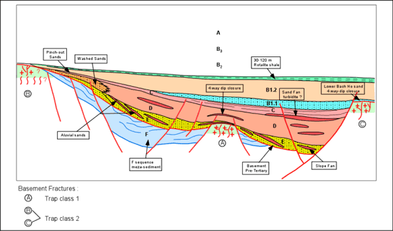
The
common source rocks in Cuu Long Basin are Oligocene lacustrine
mudstones with high TOC. Kerogen is mainly of type I/II
(oil prone). |
| |
|
| |
The
most important reservoir rocks in Cuu Long Basin are weathered
and fractured granite and granodiorite basement with more
than 1,000 m thickness. Fractures in the basement are
developed into vertically different zones with porosity
of 1-5%. Oil test rate is greater than 10,000 bopd. The
remaining proven reservoirs are Oligocene and Miocene
sandstones. |
| |
|
| |
The
Oligocene and Miocene Rotalia shale provides both vertical
and lateral seals. Local caprocks are Lower Oligocene
lacustrine clay and Lower Miocene mudstones. Trap types
encountered are: basement highs, rollover folds, tilted
fault blocks, drape anticlines and stratigraphic pinchouts. |
| |
|
| |
Prospectivity |
| |
Cuu
Long Basin is assessed to contain 20% of the total hydrocarbon
resources of Vietnam. The major petroleum plays in the
Cuu Long Basin include:
|
| |
-
Pre-Tertiary granite-fractured basement on horst or
tilted fault blocks,
- Oligocene
and Lower Miocene clastics associated with four-way
dip structures, drape above basement fault blocks,
locally by inversion.
|
| |
Cuu
Long Basin is the major source for Vietnam oil production.
Currently, oil is produced from four fields with average
of 330,000 bopd, 90% of which is from fractured basement.
With the recent significant oil field discovery, the production
is expected to increase 80,000-120,000 bopd by 2004. Also,
the basin is presently supplying all the associated gas
with production of approx. 165 mmcfd through the first
pipeline system. Eight petroleum contracts have been signed
since 1988 and 7 of them are still effective. The success
rate for exploration wells in the basin is greater than
50%.
|
|
|
| |
|
|
|
| |
Nam
Con Son Basin |
| |
|
| |
Geological
Development |
| |
Development
of the Nam Con Son Basin situated at the intersection
of two major tectonic systems related to Indochina extrusion
and East Sea floor spreading, was initiated during the
Paleogene. |
| |
|
| |
During
the Eocene-Oligocene, extension related to the early opening
of the East Sea resulted in the development of NE-SW trending
half-graben; rift sequences fill of these half-graben
are continental. As thermal subsidence set in and the
individual discrete half-graben filled, the sediment provenance
became more regional resulting in the basin-wide deposition
of high net to gross fluvial sediments from the west.
Sag sequences became more non-marine upward and more marine
west to east, due to overall transgression and backstepping
of deltas during the earliest Miocene. |
| |
|
| |
Toward
the end of Early Miocene, NW-SE extension associated with
a change in spreading direction of the East Sea led to
enhanced topographic relief within the basin centre and
structurally controlled facies pattern, in which carbonate
systems were restricted to platform or footwall locations
whilst deeper shelf and slope facies were deposited within
the graben. In the Late Miocene, the basin was again tectonically
restructured by a mild inversion, followed by thermal
subsidence, resulting in large carbonate reefal buildups
and infilled sandy turbidites, basin floor. The process
was interrupted during the early Pliocene due to a major
transgression. |
| |
|
| |
|
| |
|
| |
Petroleum
System |
| |
The
Lower Miocene paralic mudstones of the upper post-rift
are established as the major, oil prone source rocks.
Upper Oligocene coals (Kerogen type II and II, gas prone)
and Oligocene syn-rift lacustrine oil-prone shales are
also of importance.
|
| |
|
| |
Three
major types of reservoirs identified in the Nam Con Son
Basin are, pre-Cenozoic weathered fractured basement,
Oligocene and Miocene clastics, ranging from continental
deltas to deep marine turbidites in origin, and high quality
Miocene carbonates. |
| |
|
| |
There
are a variety of trap types recognised in the Nam Con
Son, the major ones are rollover folds, extensional tilted
fault blocks, basement highs and carbonate buildups. Developed
throughout the basin, Upper Miocene-Pliocene mudstones
are considered as a regional seal. Oligocene, Miocene
interbedded mudstones are local seals. |
| |
|
| |
Prospectivity |
| |
Nam
Con Son Basin is assessed to contain 20% of the total
hydrocarbon resources of Vietnam. The major petroleum
plays in the basin include: |
| |
-
Pre-Tertiary fractured granite at basement highs
- Oligocene
clastics on four-way dip structures, drape across
basement faults
- Miocene
clastics on rollover fault blocks, four-way dip or
anticline
- Upper
Miocene sandstones associated with turbidites
- Upper
Miocene carbonate platforms
|
| |
Currently,
operations are performed on 8 contracts in the Nam Con
Son Basin. Although oil is producing in Dai Hung field,
the basin is considered to have mainly natural gas potential
with proven reserves estimated at around 10 Tcf. Besides
the Lan Tay-Lan Do field with first gas in the end of
2002, other fields such as Rong Doi, Hai Thach-Moc Tinh,
etc., are scheduled to be brought on production during
the period of 2005-2007. Additional gas discoveries in
blocks 04-3, 12 have been on appraisal. The Nam Con Son
pipeline system which has a capacity of 6-7 bcm per year
marked a milestone in the development of the gas industry
of South Vietnam.
|
|
|
| |
|
|
|
| |
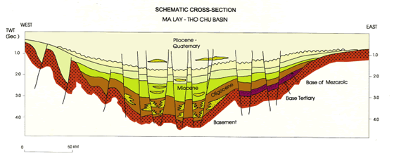
Malay-Tho
Chu Basin |
| |
|
| |
Geological
Development |
| |
Malay-Tho
Chu Basin is known as the Vietnamese part of the Malay
Basin. This can be described as an intra-cratonic basin,
which was created in Early Tertiary as a result of the
collision between the India plate and the Eurasian plate,
involving three main phases of structural deformation. |
| |
|
| |
The
first phase was related to rifting, which commenced in
Late Eocene/Early Oligocene resulting in the formation
of numerous East-West orientated half grabens, some cut
by North-South trending faults. This rift phase was connected
to the drift of the Indochina block relative to the Asia
mainland, which moved along the main left-lateral strike-slip
faults. The sedimentation in the early part of rift phase
was dominated by alluvial-fluvial facies deposited in
narrow, half-graben-like area, and followed by deposition
of a possible lake facies at the late stage in wider basin.
|
|
|
| |
The
second phase was a sag phase, which lasted until the Late
Miocene. During the Late Miocene, the transtensional stress
changed to transpressional movement, where the graben
fills were inverted, basically along East-West orientated
anticline and associated with wrench related folds. The
inversion phase ended with an eustatic drop in sea level,
causing the erosion of most anticlines. A weak extensional
phase prevailed in this area during most of the Pliocene-Pleistocene
time, which is referred to as the third phase. |
| |
|
| |
|
| |
|
| |
Petroleum
System |
| |
The
Upper Oligocene and Lower Miocene coal/claystones sequence
is the primary source rocks in the Malay-Tho Chu Basin.
The Oligocene lacustrine claystones are proven to be world
class oil source rock within the basin (Kerogen type I
and II), while the Lower Miocene deltaic and lagoonal
liptic coals and claystones are good source for both oil
and gas. The organic matter comprises a mixture of type
I and III kerogens with a probable upward trend towards
type III. The Middle and Upper Miocene sections are
therefore believed
to be more gas prone. |
| |
|
| |
Reservoirs
in the basin are primarily vertically stacked sandstones
deposited in a variety of continental to shallow marine
environment, including Oligocene deltaic, alluvial fan
and lacustrine sandstones; widely-distributed Lower Miocene
delta plain deposits, and locally Middle Miocene fluvial
and lacustrine sandstones. |
| |
|
| |
There
are a number of trap types found in the basin, such as
structures inherited from basement horsts, extension tilted
blocks, extension related drape closure, four-way dip
closure, stratigraphic pinch-outs, etc. Regional seal
is Upper Miocene-Lower Pliocene marine mudstones. Local
seal is Oligocene/Miocene alternating mudstones. |
| |
|
| |
Prospectivity |
| |
Malay-Tho
Chu Basin is assessed to contain 5% of the total hydrocarbon
resources of Vietnam. The major petroleum plays in the
Malay-Tho Chu Basin include: |
| |
-
Oligocene sandstone anticlines or fault blocks (may
be associated with extensional tilted blocks
- Lower/Middle
Miocene sandstone anticlines or fault blocks
|
| |
There
have been 3 petroleum contracts signed. For the Vietnam-Malaysia
overlapping overlapping area, the first discovery Bunga
Orkid was made in 1991 followed by a series of other oil
and gas discoveries. Currently, the Bunga Kekwa field
produces approximately 15,000 bopd; adjacent fields are
developing. With the area's proven reserves of about 6
Tcf gas, the second gas pipeline system with capacity
of 1.5-3 bcm per year has been scheduled to complete in
2005. |
| |
|
| |
|
| |
|